
Map and Directions to OIC
Osaka International Church (OIC) serves foreign and Japanese residents and visitors in the greater Osaka area. The church location is very convenient for Osaka residents, and it is also within reasonable commuting distance for people coming from Kobe, Kyoto, Nara, and Wakayama.
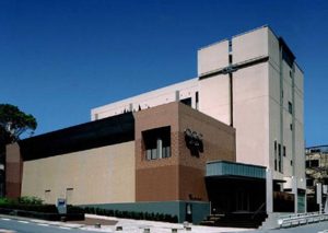
※Osaka International Church (OIC) rents the hall on the 1st floor of OCC for Sunday services.
Train Transfers
Local Map and Directions
General Location
By Train
OIC meets in the Osaka Christian Center, which is a short walk from the Tamatsukuri Station on the JR Loop Line in central Osaka City. If you get the best train connections, travel time to JR Tamatsukuri from JR Kobe is 45 minutes, from JR Kyoto 48 minutes, from JR Nara 45 minutes, and from JR Wakayama it is 76 minutes. If you are coming for the first time, please allow extra time since actual travel times will vary some depending on the train.
By Osaka City Subway
Many people living in Osaka City will find that the city subway is the most convenient way to come to church. OIC is a short walk from the Tamatsukuri station (station #N19) on the Nagahori Tsurumi-ryokuchi line (lime-green line). Johomaps also has this more detailed subway map.
By Car
It s also okay to come by car, but most people will probably find the train or subway to be more convenient. We apologize for the fact that there is limited parking space and no free parking. The church is located just a little bit south of Osaka Castle Park which is easy to find on most maps. The Road Access Maps at the bottom of this page will help you to see the location, but they are in Japanese only.
Train Transfers
If you are are unfamiliar with the JR Loop Line, you can consult the following map and the list below it for the easiest places to transfer.
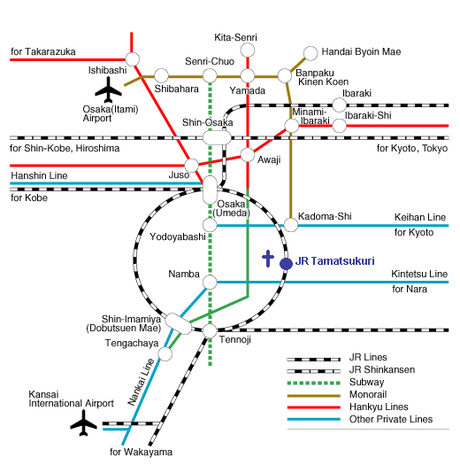
Transfer Station List
- From Kobe, Kyoto, etc by JR, transfer to the JR Loop Line at Osaka station (Kyobashi direction).
- From Kobe, etc by Hanshin, get off at Hanshin Umeda, walk to JR Osaka across the street and take the JR Loop Line (Kyobashi direction).
- From Kyoto by Keihan, change to the JR Osaka Loop Line at Kyobashi station (Kyobashi direction). Kyobashi is not shown on the map above, but the JR and Keihan stations are right next to each other.
- From Nara by Kintetsu, change to the JR Loop Line at the Tsuruhashi station (Kyobashi direction). Tsuruhashi is not shown on the map, but the JR and Kintetsu stations are in the same location, and you can directly transfer through a transfer gate.
- From Nara, Wakayama, etc by JR, change to the JR Osaka Loop Line at Tennoji (Kyobashi direction).
- From Wakayama, etc by Nankai, change to the JR Osaka Loop Line at Shin-imamiya (Tennoji direction).
Local Map and Directions
 From Tamatsukuri JR Station (Osaka Loop Line)
Walk through the ticket gate and continue straight ahead in the building, past the McDonald’s. At the end of the building you will be facing a large street (Nagahori-dori). Turn left (west) and walk along the street until you come to an intersection called Karahori-cho (intersection name signs are mounted on the signal light poles). Karahori-cho will be the fifth traffic signal fromTamatsukuri Station (counting the one right in front of the station as the first), and the walk will take about 10 minutes. Turn right at Karahori-cho, and after one block you will see the Osaka Christian Center (OCC) on the right-hand corner.
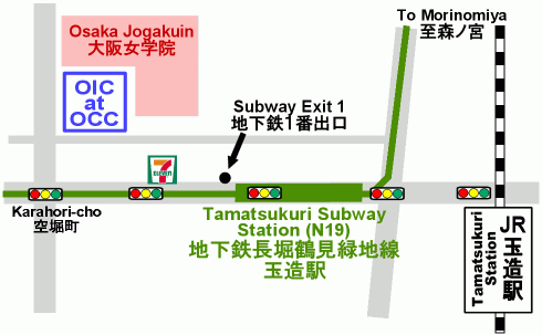
 From Tamatsukuri Subway Station
After exiting the ticket gate, follow the signs to Exit #1 (left down the hall). When you emerge from the exit, you will be facing a large street from the north side (see black star in above map). Turn right on the sidewalk and walk to the second traffic light, which will be the Karahori-cho intersection. Turn right, and after one block you will see the Osaka Christian Center (OCC) on the right-hand corner.